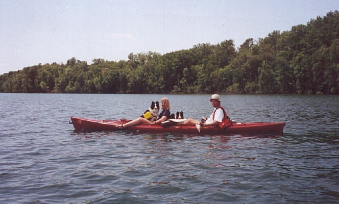
March 26th, 2000 - Colby Lake, Washington County
Took the kayak out for the first time. Realized pretty quickly that
tandem kayaking could be a great way to ensure a domestic quarrel. The dogs came along with their little life jackets. They didn't
seem freaked at all. We got pretty wet...the wind was creating whitecaps
on the lake. Decided we needed to get a rudder. |
April 16th, 2000 - Mississippi River in Brooklyn Park, Hennepin County
Started at the Coon Rapids dam and kayaked about 3 miles down the river.
Stopped on the island and looked around. Took about two hours total. |
April 29th & April 30th, 2000 - Caribou Lake, Itasca County
Jeff, JoAnn, Cammie, and Molly (Stearns) kayaked about the lake. It
started raining, and we all got crabby. Couldn't keep the kayak going
straight. We need a rudder!! |
May 28th, 2000 - Rice River, Itasca County
First real kayaking adventure! Started in a chain of small lakes
(Copenhagen, Heinen, Slauson, Cameron) and then traveled down the winding
Rice River. Total distance: 10 miles. Including lunch, the trip took 7 hours
from put-in to take-out. We were worried that we wouldn't get to the end
before sundown... The trip was a bit more wild than expected: We had to
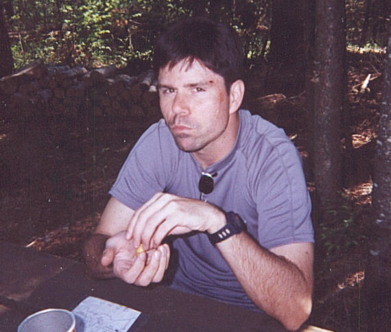
portage over a few beaver dams and downed trees. JoAnn whacked me over the
head with her paddle and made me bleed. We saw a lot of wildlife: Deer,
beavers, ducks, and mergansers. Use of Jeff Blesi's GPS turned out to be
critical for finding our way out of lakes. It was so cool we had to get
our own.. Garmin
Mapsource file |
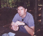
Whacked with a paddle by wife and not happy (click for big photo)
|
July 3rd, 2000 - Trout Lake, Itasca County
Jeff, JoAnn, Molly and Cammie put in on the north end of Trout Lake with
their friends Heidi and Todd. We paddled down about 1.5 miles to the Joyce
Estate where we had lunch. Fished all the way back. Found a sand bar in the
middle of the lake where the water was only three feet deep (N47.47403
W93.54767). |
September 4th, 2000 - BigFork River, Itasca County
Started at Hafeman's
Access about 6 miles west of BigFork (N47.74872
W93.77753) and took a 9.1 mile tour of the BigFork
River, ending in BigFork (N47.74444
W93.65407). Pretty tame. Stopped halfway for lunch (N47.74203
W93.70966). The entire trip
took just under four hours. Spotted several otters, ducks, geese and blue
herons. Used my GPS on a river trip for the first time, although we didn't
really need it. JoAnn and I are getting much better at tandem kayaking! Garmin
Mapsource file |
May 24th, 2001 - Trout Lake, Itasca County
First trip with our new rudder. Basically the same trip
we did on the last fourth of July, except with JoAnn's parents this time. We
went a little south of the Joyce Estate (N47.46393
W93.55251) and tried to navigate up a stream to an adjacent lake, but the
stream was too shallow. 5.4
miles. Garmin Mapsource file |
May 28th, 2001 - BigFork River, Itasca County
Harrison's Landing
Campground (N47.76198
W93.90660) to Hafeman's Access (N47.74872
W93.77753), where we started our first BigFork trip on 9/4/2000. Navigated two Class I rapids, but the water was so high that we
didn't know we went over them... 10.5 miles. Garmin
Mapsource file |
July 7th, 2001 - Suomi Hills Lakes, Itasca County
Started in Adele
Lake, paddled into Doctor Lake, and then portaged to Spruce Island Lake.
Tooled around there for a while, and then proceeded back over the portage,
through Doctor and Adele Lakes to Beaver Lake. Finally, we returned to
Adele and made our exit. Spruce Island looks like a great place to camp (N47.46306
W93.65546)! Total
trip, approximately 3 miles. Garmin
Mapsource file |
July 15th, 2001 - Minneapolis Lake System, Hennepin County
Windy
day. We put in on Calhoun (N44.94955 W93.31263)
and went under bridges to Lake of the Isles and Cedar
Lake. Made a pit stop at one of the beaches and then went through a culvert to
Brownie Lake. Tooled around and headed back to Calhoun. Total trip: 4.2 miles.
As a note, these lakes are fairly shallow and weedy...ick! Garmin
Mapsource file |
July 22nd, 2001 - Sunrise River, ?? County
Holy Cow. We set
out with our friends Steve and Paula around 10:30 (got a late start due to the
weather). Put in Just above the Kost Dam. 11.2 miles, 4 hours 56 minutes,
several rapids and many downed trees later (we had to get out of the kayak at
least 7 times to carry it over trees), we took out just in St. Croix Wild River
State Park. BTW, Steve and Paula swamped their kayak 6 times. One time was
caused by Paula when she saw a spider and freaked out. Garmin
Mapsource file |
August 25th 2001 - St. Croix River, Washington County
Put in at
Taylor's Falls at 10:12am. Our neighbors Bill and Judy rented a canoe, as
did Judy's sister Rose and her husband Patrick. We took our time
meandering down the river. We stopped at Osceola at 11:54 (now 5.9 miles
into our trip) and had lunch for about 1/2 hour. We hopped back in the river at
12:30 and the sun came out. We finished the final 8.8 miles of the trip and took
out at William O' Brian State Park at 3:02pm. Total trip: 14.7 miles. Although
this was our longest trip yet, it didn't seem that long due to the fact that
this river was fairly straight. Garmin
Mapsource file |
September 3rd, 2001 - Prairie River, Itasca County
This was Patty B.'s favorite trek to date. We (JoAnn, myself and her parents)
put in at the public access on Prairie Lake (just east of God's Country
Outfitters off of Highway 38) and kayaked down the Prairie River to Highway 2,
just before the Prairie flows into the Mississippi. We started out paddling
south across Prairie Lake to "The Gorge" and then into Lower Prairie
Lake. We took out at the south end of Lower Prairie and portaged 1/3 mile
around the power plant to the Prairie River. After lunch, we put in and
finished the final portion of our trip. The last section of the river featured
some fun rapids. Total trip: 9.2 miles. Garmin
Mapsource file |
May 27th, 2002 - BigFork River,
Itasca County
JoAnn, myself, Pat and Jeff started in BigFork (where we ended our
trek on 9/4/2000). Traversed two sets of rapids.
The first, Rice Rapids, was a 1/2 mile long and bouldery class I rapids.
Fun...we got wet, and the water was pretty cold. We had lunch on
somebody's property after we gave up looking for a public spot. We hit the
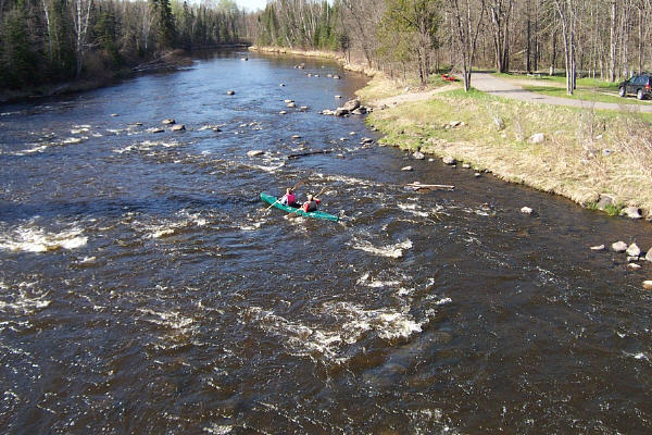
second set of rapids, another class I but shorter than the first, right
before the takeout (see the picture of Pat and Jeff to the right). On this
trip, we spotted a deer, a few otters, ducks, geese (both Canadian geese
and pet geese), dogs, King Fishers, and various other birds. Total trip:
14.11 miles. We've now kayaked 33.71 miles of the BigFork river. Garmin
Mapsource file |
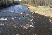
Pat and Jeff master the rapids on the BigFork (click for
a big photo)
|